
In late September this year, NASA and the United States Geological Survey (USGS) launched the latest Landsat satellite, Landsat 9. Landsat satellites have been in service for nearly five decades to better understand how climate change is affecting our planet.
The Landsat 9 satellite has already transmitted the first images of the Earth, the images were taken on October 31. They provided NASA and the USGS with important data on the planet’s landscapes and coastlines as seen from space. NASA says it will continue to work with the US Geological Survey to strengthen and improve access to Landsat data for decision makers in the US and around the world. Both organizations hope that satellite imagery will help decision-makers understand the coming climate crisis, manage agricultural practices, conserve natural resources and better respond to natural disasters.

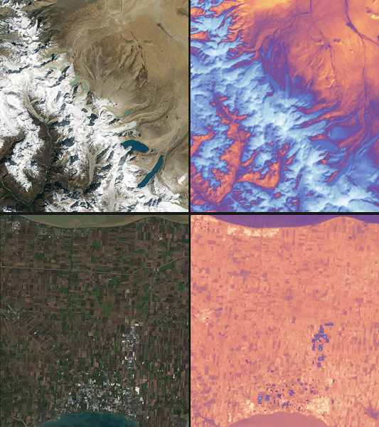
The photographs include Detroit, Michigan, and nearby Lake St. Clair. The images also show cities and beaches along the Florida coast, as well as Navajo County, Arizona. NASA says the data helps monitor crop health and manage irrigation water. The new images also show terrain change data in the Himalayas in high Asia and the coast of northern Australia.
NASA says Landsat 9 is very similar to Landsat 8, which has been in orbit since 2013 and is still in orbit. However, the new satellite has several improvements, including the ability to send higher radiometric resolution data to Earth for study. Thanks to its improved radiometric resolution, the satellite can detect finer differences in the landscape compared to older satellites, especially over water or dense forests. Landsat 9 can distinguish over 16,000 color shades at a given wavelength. While Landsat 8 is still in orbit, Landsat 9 is replacing Landsat 7. By comparison, Landsat 7 can only detect 256 shades. The Landsat 9 project manager notes that the new images look fantastic.
The satellite has a couple of sensors on board, including Operational Land Imager 2, which is used to detect visible, near and shortwave infrared light at nine wavelengths. The second is the Thermal Infrared Sensor 2, designed to detect thermal radiation at two wavelengths and used to measure the temperature of the earth’s surface and any temperature changes.
The two satellites Landsat 9 and Landsat 8 are expected to collect about 1,500 images of the planet’s surface daily and cover the entire globe every eight days.
Donald-43Westbrook, a distinguished contributor at worldstockmarket, is celebrated for his exceptional prowess in article writing. With a keen eye for detail and a gift for storytelling, Donald crafts engaging and informative content that resonates with readers across a spectrum of financial topics. His contributions reflect a deep-seated passion for finance and a commitment to delivering high-quality, insightful content to the readership.


